Ask an Engineer – Part 1
Can you accurately model wire positions in PLS-CADD, when there is wind blowing the conductor during a LiDAR survey?
One of our clients had a question about performing a LiDAR survey when there was significant wind, and wanted to know how this would affect the accuracy of the survey. If the purpose of the survey is to be able model the line at max blowout position, you need to model the line plumb in the first instance.
In my view this comes down to knowing at what point we should apply a correction or even not fly the circuit. When does the wind factor become enough to affect the quality of the conductor sag in the PLS-CADD model? These numbers would vary depending on the conductor span length, the conductor weight and the conductor diameter. The horizontal loads which will cause the conductor to deflect are the wind pressure multiplied by the conductor diameter. The conductor weight will cause the conductor to remain plumb.
As an example I have run some numbers for Araucaria 700mm², with a span length of 300mm.
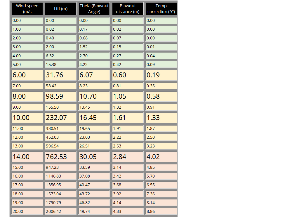
The diagram shows that the deflection up to 6m/s is trivial, with a 6 degree blow out angle, which causes a delta sag of 31mm. At numbers above 6m/s we may wish to consider sag correction. For example, at 8m/s we have a blow-out angle of 10.7 deg, with a delta sag of 98mm; while at 10m/s we would have a blow-out angle of 16.5 deg with a delta sag of 232mm.
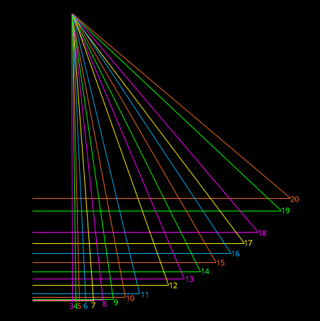
The wind speed here is, of course, the component which is perpendicular to the conductor; as a power line will have numerous changes of direction it is prudent to consider the worst case wind and accept that most spans will not be so badly affected. There are exceptions to this, in certain areas where prevailing winds arise we may wish to only consider the higher wind events where they are occurring perpendicular to the conductor, or are determining the perpendicular and parallel components from that prevailing wind direction.
At some point, the helicopter pilot may decide that the winds are causing excessive crabbing meaning that making the required survey flight problematic, I am not considering that as part of the scope of this blog. Purely in terms of excessive angle and delta sag, corrections to the sag delta would cease to be as effective for larger blow out angles and sag changes; with this in mind, it is normally prudent to suspend LiDAR survey at wind speeds of 14m/s and higher.
As Director of Engineering and heading up research and development at NM Group, Paul Richardson is a renowned power industry expert and long-time proponent of the use of 3D modelling in improving reliability and utilisation, while minimising cost. He is a chartered civil engineer (BEng Hons, CEng, MICE), and retains a wealth of experience, including more than 20 years of power line engineering.
Paul will be answering more questions as part of the Ask an Engineer blog series. So, if you have a question about LiDAR, PLS-CADD or any aspect of power line engineering, please email info@nmgroup.com.