How can the Telecoms industry benefit from geospatial technology?
While NM Group’s primary client base is in the power industry, recently we have undertaken some trial projects with a major UK telecommunications company. UK and Europe Business Development Manager, Scott Haslam, talks about the benefits a geospatial approach could offer telecommunications operators:
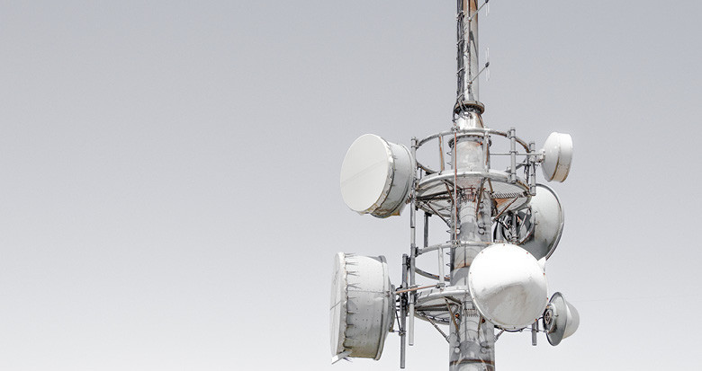
“Network signal can be made more reliable by using geospatial data. A telecoms operator has towers with microwave receivers. If there are any obstructions between two receivers, you lose signal on your mobile phone. Vegetation, buildings and even heavy rain can affect the line of sight. NM Group's services enable a client to pinpoint the location of a microwave link obstruction, whether that be a building or tree vegetation.”
Point to point surveys to maintain network reliability
“A point to point survey is carried out in exactly the same way as a powerline survey. We capture LiDAR data using a wide area survey and our expert technical team process the data. The client receives thorough and accurate reports for each link. Any line of sight constraints at the required frequency are highlighted and remediation options recommended. If it’s a building, we might advise moving the antennas. Or if its vegetation, 80% of the time we can advise to go and cut down the tree or particular branch affecting transmission.”
Vegetation management expertise
“NM Group have ten years’ experience in LiDAR capture, processing and supporting vegetation management operations. We're able to tell a client where they need to cut a tree and the precise location of an obstruction. We can tell how high on the transmission tower the antenna needs to be to achieve line of sight. As well as identifying line of sight constraints, we can also provide a buffer of 5m. Anything within 5m of encroaching the microwave link can be flagged to the client. As experts in assessing data for vegetation management, our analytics can predict tree growth. Offering providers a proactive approach to network management and safeguarding the telecoms network now and in the future.”
“…our services are fairly unique, enabling a client to pinpoint the location of a microwave link obstruction, whether that be a building or tree vegetation.”
Cost efficiency in new network construction
“NM Group can also help with planning for new network construction. If a new microwave link is required, we can help a provider to understand the best location for each tower and what frequency the link needs to be at to gain a microwave, with a comprehensive view of the environment surrounding the link. Because we capture data for a 300m corridor, our clients can plan better. Avoiding the repetition of expensive design work. Given that fibre is more expensive than microwave links, this service offers clear cost savings for network construction.”
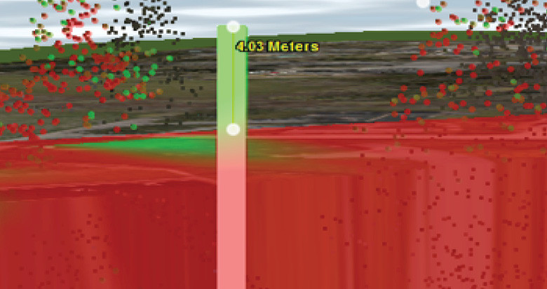
Using Caydence® to understand tower clearance
Innovation
“Caydence® is our online 3D software program. It gives great contextual information, cutting down the need for site visits and reducing costs. Safety is also improved as more detailed risk assessments can be conducted from the desktop. It can be used in analysis and planning for telecoms networks. Having your data and being able to manipulate that data is really important in that you can do a field of view check from tower to tower. Caydence® also allows you to work on preliminary designs and view the site in 3D. Being able to better understand the network and its environment improves efficiency, enables better informed management decisions and helps make network signal more reliable.”