Using remote sensing to understand change over time on a power network

By Tim Hustwayte, Senior Client Manager at NM Group
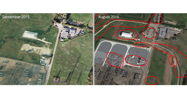
Change detection is the comparison of a number of different datasets to identify and objectively quantify what has changed. This could between any two datasets, but specifically for this article I am considering spatial data. In my line of work this typically consists of comparing images or 3D LiDAR data for a specific area over multiple time periods. Using specialist processing workflows, the data comparison can be analyzed to highlight any variation. As an example this might be looking at how much ground movement occurs, the number of new buildings constructed or measuring how much vegetation grows over a year.
Why is this of interest for electricity network operators?
All of which is interesting in a purely academic way, but how does it help an electricity network you may ask? Dispersed linear assets like electricity networks are typically vast, and inspecting the entire length can be a costly and slow process. Remote sensing rapidly collects image and 3D data that can be used to highlight the degree and location of change. It is a powerful tool in better understanding not only what is going on around the network, but also why change is happening, allowing a utility to make better operational decisions.
Some example uses for the technology
One of the most useful applications is being able to understand what unplanned or unauthorized activity is happening on the network. Due to its very nature, this can be hard to identify, yet undiscovered, can cause significant issues. This might range from subsidence affecting a critical tension tower, or a new temporary building built below an HV power line. Being able to manage this kind of risk is vital to a network operator.
Change detection can help optimize vegetation cutting along a network. Trees are normally pruned based on whether or not they infringe a minimum clearance distance. Usually this distance includes a buffer for growth between cutting cycles. Change detection allows this buffer to be tested and refined based on empirical evidence for growth rates. Yes, this has to be treated carefully due to seasonal variation, however it provides an excellent data input for more efficiently managing vegetation.
How can you ensure contractor accountability? The ability to compare the network environment both before and after the work is completed provides an objective view. Whether for vegetation cutting contractors or construction work, using change detection algorithms provides an independent comparison.
Summary
As with all the examples the ability to compare two or more sets of highly accurate 3D data can be used for determining trends. How much is the terrain changing? What additions are there to the built environment? How quickly are assets being updated? Mining the information over a number of years helps to answer all these questions. Ultimately this provides strategy makers with the ‘big picture’ view to better work out exactly what is happening, and from there, take the most effective course of action.
Find out more about change detection.