How the UK DNO market is benefiting from network wide geospatial data
By Tom Hall, Director at NM Group
As a director at NM Group I have been able to observe the sustained drive within the UK distribution space for new innovative methods to efficiently manage networks. Specifically, the RIIO model (Revenue = Incentives + Innovation + Outputs) is promoting Distribution Network Operators (DNOs) to look at new ways to reduce total spend while maintaining or improving network quality. No longer just targeted on capital or operational spend, network operators are now looking for efficiency savings from innovation to help determine incentivised elements of their revenue. The demand for efficiency saving and innovation in particular has led to a change in the approach to asset management. An example of this is the use of geospatial analysis to aid utilities’ decision making.
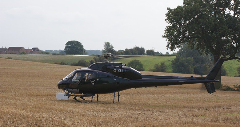
The collection of geospatial network data such as LiDAR or imagery is not new to the DNO market, indeed it has been used to a greater or lesser extent for many years. What is new is the scale and speed of the data capture methods. Both hardware and web-based technologies are now mature enough that an all-of-network methodology is both cost-realistic and effective. UK DNOs are using this approach to gather asset position and condition information for their entire service areas, creating a complete and detailed asset inventory. In this article I want to explore how DNOs are seeing real benefit in using this rich dataset across different business areas such as vegetation management, asset management and OHL engineering.
Why is this happening now?
Before I look at how this is working, let’s review why this is happening now. Previously, large numbers of assets and a wide range of voltages meant the data acquisition costs to DNOs have been high. Transmission utilities have used this approach for years, but the smaller capital value of distribution assets meant that there needed to be a swing in the cost-benefit equation. The latest generation of remote sensing hardware, smart processing methodologies and financial incentives such as RIIO have resulted in the last few years becoming the proverbial opportune moment.
Through these software advances, reporting methods have moved to the point where it is now possible to easily view the data and seamlessly ingest it into existing corporate systems. The upshot is the ability to have this data made widely accessible to the organization, not just a small specialist data team. This is crucial, as a large part of the benefit of improved asset data is only realized if the organization as a whole can access and use it as part of their everyday work.
UK Power Networks
UK Power Networks (UKPN) implemented a remote sensing led asset-wide mapping strategy as ‘business as usual’ in 2014. Having previously secured funding for this innovation in 2013 using the Innovation Funding Incentive (IFI), they contracted NM Group to explore, trial and deliver what the benefits of such a project might be. The main objective was to target and potentially reduce the management cost associated with tree trimming and to improve network resilience.
3D data of both the assets and surrounding environment provides clear analysis of the network, demonstrating which areas are vegetated and how severely, instantly improving scope for cutting contractors. The analysis pinpoints the location of the worst case infringements, prioritizes work orders and avoids ground- based patrols where no vegetation is present.
UKPN are now working with NM Group as part of a long term framework where data is presented in our 3D asset management system, Caydence®. This enables users to conduct desktop patrols and complete virtual scoping, both in the office and in the field on ruggedised devices.
Ian Draper at UK Power Networks commented on the project; “The inclusion of 3D visualization technology enables us to better judge the damage risk to our network from trees and other vegetation, and helps us to manage our contractors more effectively. This will assist in realizing significant cost savings and further improve the reliability of power supplies for our customers”.
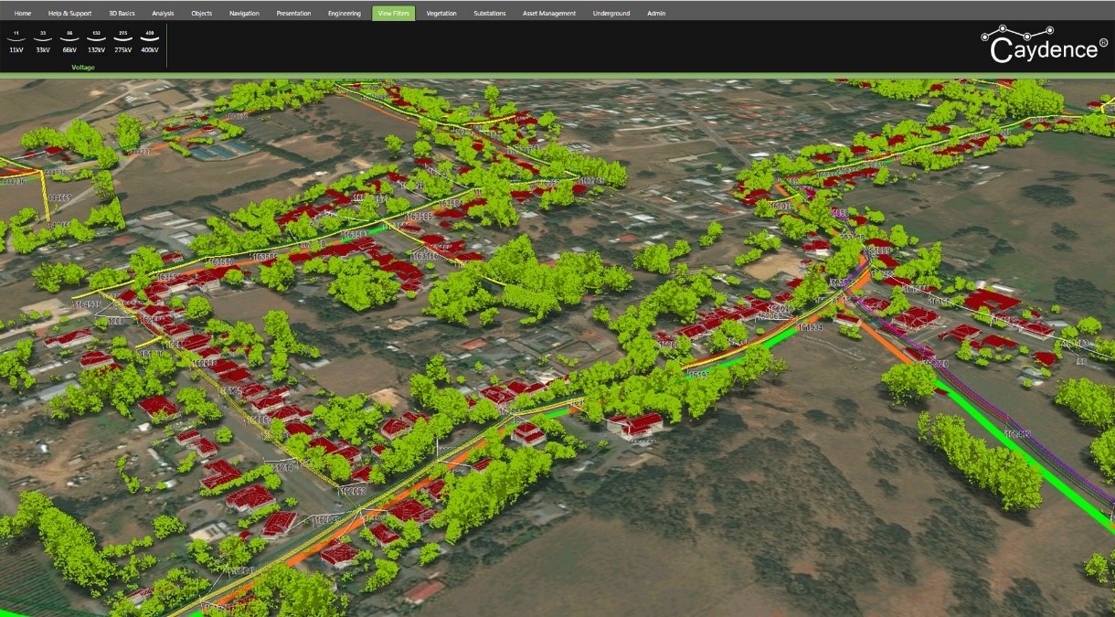
Geospatial data presented in a 3D asset management system
Scottish and Southern Electricity Networks
Scottish and Southern Electricity Networks (SSEN) also realized the benefits of this technology and began implementing an all-of-network approach in 2016. Their motivations were to both improve network resilience and to better understand the environment surrounding their assets. Implemented without innovation funding this project demonstrates the maturity of this technology in the DNO space and evidences this as best practice for wide spread asset data collection.
The 3D model of overhead lines will reduce the requirements for foot patrols, resulting in more time focused on other network risks in an effort to improve network outages and better plan for storm incidents. In both cases, enabling a more reliable, safer network resulted in less customer minutes lost. Additionally, having such a comprehensive network model will allow SSEN to better plan their future asset needs and improve the quality of new line connections, reducing the cost and completion time.
Stewart Reid, Head of Asset Management and Innovation at Scottish and Southern Electricity Networks, said: “The partnership with NM Group and the use of LiDAR will have a significant impact on the resilience of our network. It will help ensure we are able to identify and mitigate any risks and allow us to rectify any problems. This should result in better security of supply to our customers.”
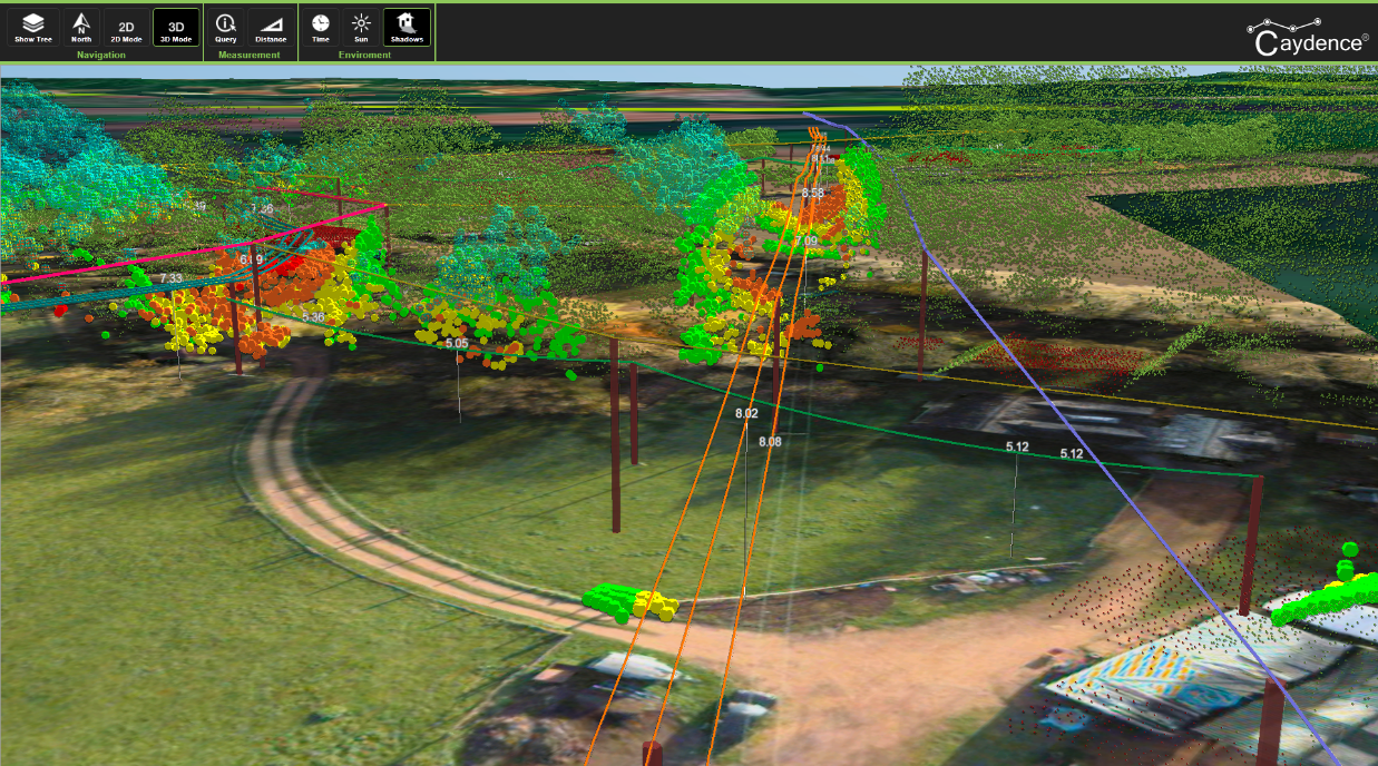
Reducing the risk of tree related outages is one of the primary reasons DNO’s are using geospatial data
Conclusion
So what benefit does the all-of-network method provide for UK DNOs? I believe collecting this data for an entire system brings further value in the form of a complete and holistic view of all assets. Now every area, circuit and span is mapped along with the surrounding environment, allowing decisive and accurate management decisions to be made with reduced need for field visits. It provides an accurate baseline to work out real operational costs and provides the best intelligence for future cost forecasting.
There are still areas for refinement which mean the potential value of this approach can only grow further. Making sure the approach will mesh with existing operational policies and that the data is distributed widely within the business is critical to achieving the best return. Sensible precautions when adopting this approach include making sure that you retain data ownership and that provided file formats are not locked to any particular software or supplier. This is important to ensure the most ‘future-proofed’ option.
To summarize, an all-of-network approach to collecting geospatial asset information provides greater benefits than the individual sum of its parts. Better information means better decision making throughout all departments of a utility. Fundamentally, with a greater understanding and certainty of the risks to the network, DNOs are armed with the best information to ensure the lights stay on at the lowest operating cost.
Bio: Tom Hall
Tom leads the sales activities for NM Group, promoting the appropriate application of asset management services, data analytics, and the spatial information behind them. Starting out as an apprentice in the industry, Tom has now been with NM Group for 4 years. He is a highly experienced industry specialist of 18 years, with a strong technical background in LiDAR, photogrammetry, GIS and it’s exploitation.