More common questions utilities ask LiDAR providers

By Tim Hustwayte – Senior Client Manager
Missed our first client FAQ blog – read it here.
Here are another set of common questions power utilities ask us when discussing LiDAR data projects. Read on to find out what are the most frequently asked questions are and what you really need to know to get the best possible project outcome.
1) Aren’t 3D visualization platforms doing the same thing as the corporate GIS?
A key part of our service delivery, particularly for vegetation management, is to provide a 3D view of the lines, ground and trees along with reporting and measurement tools. However, we’re often challenged and asked something like ‘how does this differ from our GIS’?
It is a great question – and a fair one. We see the corporate (or enterprise) GIS as representing a single source of truth on the position and attributes of network assets. The data that makes it into this system is subject to robust validation and is updating procedures and a range of governance rules. It is a core part of the utility information infrastructure alongside the asset management system.
The type of system we provide has been designed to complement this GIS capability and deal with things that aren’t practical for the enterprise system. We deal with data that has a very time limited value – the position of the conductors at the time of survey and the current state of the trees. This information would have no place in the GIS yet it is crucial to vegetation managers.
The requirement to rapidly provide this information to utility users (often as quickly as a few days after data capture) also means that ingesting it to a corporate system will be highly resource intensive, or even impossible. Finally, we’ve geared this platform to run over the web AND take hundreds of gigabytes of mass LiDAR data – it can’t do what the GIS can, but it can stream the virtual representation of the 3D world.
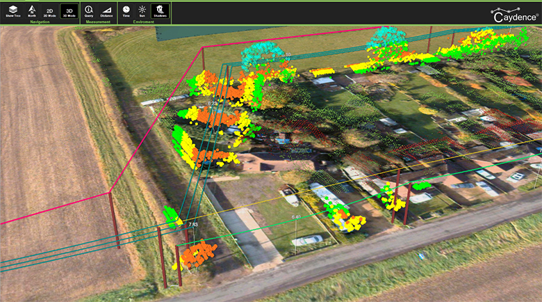
Example of a user planning vegetation cutting using accurate data within a 3D environment
2) Is Geiger-mode/single photon LiDAR going to replace linear LiDAR?
Geiger-mode or single photon LiDAR has been made available to the commercial market recently. These technologies use a different approach to measuring the returning photons to acquire dense LiDAR data from higher altitudes – giving real benefits in terms of efficient coverage and consistent datasets across the project area. Trade-offs can include more limiting weather windows, the need to fly at night (in some cases) and the higher degree of noise in the data compared to waveform LiDAR.
These technologies can have real value for a utility in terms of consistent network coverage at a high resolution – whether commissioned directly or as a spin off to a separate acquisition campaign by a third party (say for a state-wide program). The mass coverage is particularly useful for highly dispersed distribution assets, useful for updating pole positions, defining geographic connectivity and calculating vegetation clearances, for example.
So will it replace linear LiDAR? Probably not. We see it as another tool in the utility toolbox, to complement LiDAR and imaging from fixed and rotary wing aircraft. The different sensors and flight regimes, combined with the size and layout of the network, capture and delivery timescales and budget will all come into play. For example, it isn’t likely to be a practical tool for annual revisit for vegetation mapping in early leaf-on conditions and won’t necessarily come with high resolution imagery.
Geiger mode and single photon are fantastic technologies and are likely to find a strong complementary niche to existing techniques.
3) What is the typical turnaround time to process LiDAR data for a utility?
The simplest answer to this question is that there is no typical turnaround time! In some cases we will provide data within 1 week of acquisition where rapid access to the data is needed (say in a post storm assessment) and in other cases (such as modeling 10,000 miles of network in PLS-CADD) this will be carried out over a year.
Some of the variables at play will include the complexity of the product set, the degree of manual data cleaning, the quality of the source GIS/Asset information and the size and shape of the network. Also important, where quicker turnaround is required, is time to adequately plan flight logistics and test and refine any workflows and deliverable products well before capture commencement.
In general, most things are possible – from 3 weeks post-flight for a vegetation report through to 6 months for a new line design. What makes either possible is adequate time to plan, test and evaluate – meaning a collaborative approach to procurement with knowledge of the risks and constraints to timelines.

There is no simple answer as schedules depend on the individual project variables
4) How can achieve more value from our geospatial data/LiDAR project?
Getting more value in this context means finding more than one use for data and models, ideally so that other costs are offset or processes made more efficient within the utility. Fortunately, transmission and distribution projects based on remote sensing from aerial platforms offer significant scope. Ideally, this is something that is considered in the planning phase so that the specification considers the value options, rather than something that is reviewed once a project underway. Areas where extra value can be found include:
Specify data so it is available to multiple users. For example if you are acquiring data for use in an engineering model it can likely be adapted to report on vegetation infringements for use by vegetation management users. It may also be used to update the asset register, providing up-to-date structure locations and property boundaries for asset management or real estate.
Find data capture synergies. In many cases utilities will fly helicopter patrols for close up asset inspection sorties, such as spotting pole defects. Often a LiDAR mission is also be flown later in the year for monitoring vegetation compliance. Using the latest technology it is possible to combine the two projects in one flight and reduce the OPEX burden.
Sharing the data widely. Another area to consider is how will the data be used and distributed around the business to ensure the full benefit of the information is realized? Going 3D provides an option, but also consider data feeds that automatically update corporate GIS or management systems to ensure data is updated regularly.

Multiple uses from a single data capture project deliver more organizational value