Rapid Vegetation Management: A Collaborative Success Story
- Rapid identification of critical vegetation infringements using aerial LiDAR technology
- Actionable, accurate data insights are produced and delivered within 24 hours.
- Swift client response to prevent the vegetation risks within the transmission corridor.
- The follow-up survey verified and quantified the vegetation removal works.
Vegetation management is critical for ensuring the safety and reliability of power transmission infrastructure. Managing vegetation encroaching on powerlines for transmission utilities isn’t just a routine maintenance task; it’s a vital piece of risk mitigation strategy. Rapid identification and response to vegetation infringements are essential to preventing potential power outages and ensuring public safety.
At NM Group, we deliver cutting-edge solutions to help utilities stay ahead of such risks. Recently, during our annual project for one of our clients - a major transmission network operator - we saw firsthand how our technology, combined with the client’s swift response, enabled efficient management and auditing of a critical vegetation issue.
Advanced Technology for Real-Time Risk Reporting
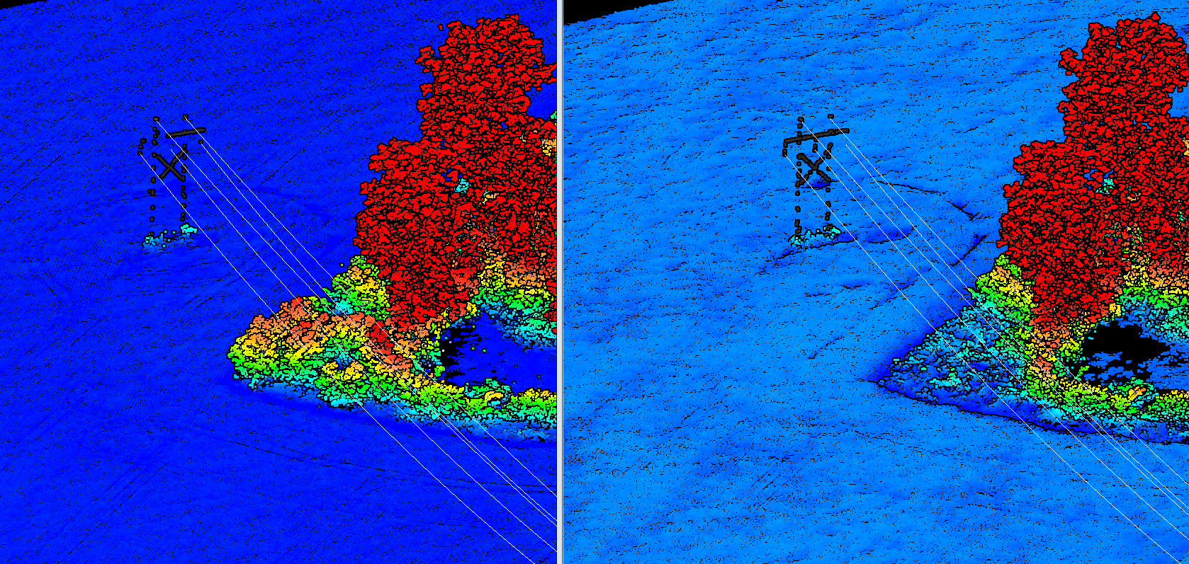
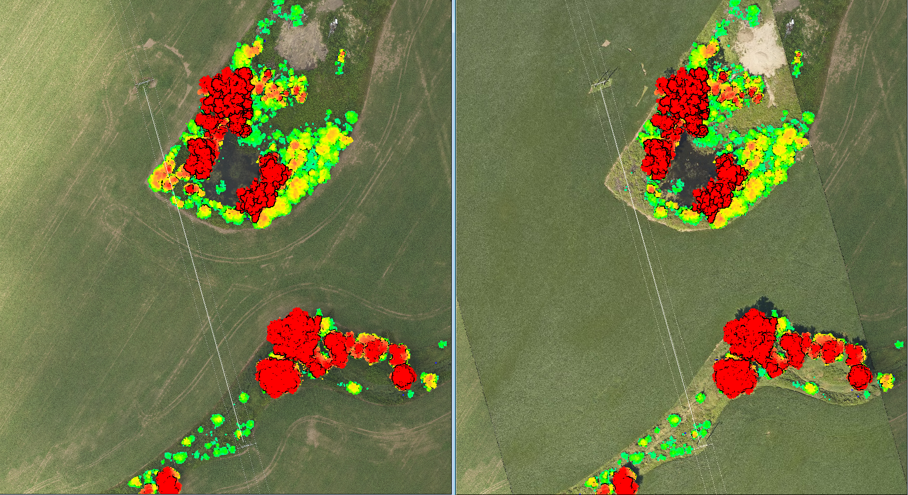
This summer, as part of our annual program with our client, we conducted an aerial LiDAR and imagery survey across their network to assess, analyze, and report on vegetation encroachments. Thanks to state-of-the-art equipment and advanced data processing workflows, our team processed the data immediately after the flight and reported on a possible 'Critical' vegetation infringement. Within 24 hours, the client received a precise location of the potential issue and a highly accurate calculation of the distance and scale of vegetation encroachment against the internal utility standard. In addition, the data was formatted to incorporate utility-specific reference data and included visual aids to help ground crews locate and access the relevant span easily. This rapid reporting allows utilities to identify and address potential risks before they escalate into more severe issues.
Swift and Effective Action
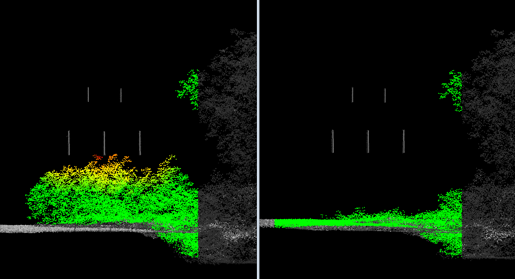
Using the report provided by NM Group, the customer had all the necessary data to action the vegetation-cutting work. Within 24 hours, the field crews mobilized to the location and, using the detailed information from our report, quickly validated and cut approximately 110 m² of vegetation across a distance of around 22 meters within a single conductor span, addressing potential issues before they could arise.
LiDAR for Planning Vegetation Management
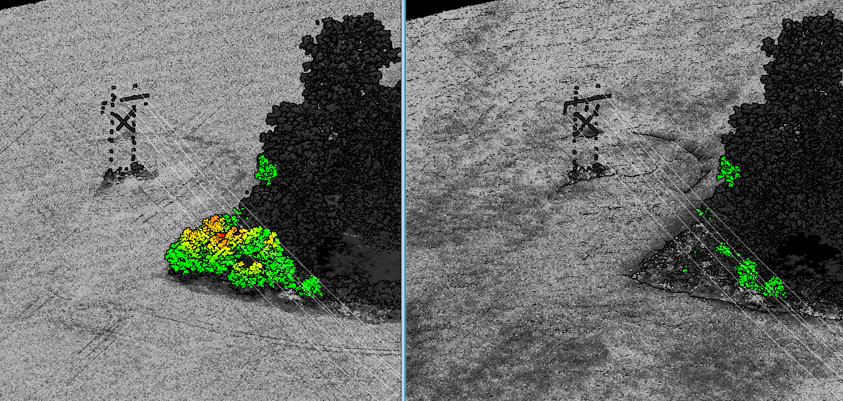
A month later, while surveying nearby areas, the previously flagged section of the circuit was captured again. This second aerial LiDAR survey provided an opportunity to check for new infringements and audit the effectiveness of the previous vegetation clearance. Our client had acted swiftly, removing the vegetation that had previously restricted right-of-way access and threatened their powerlines.
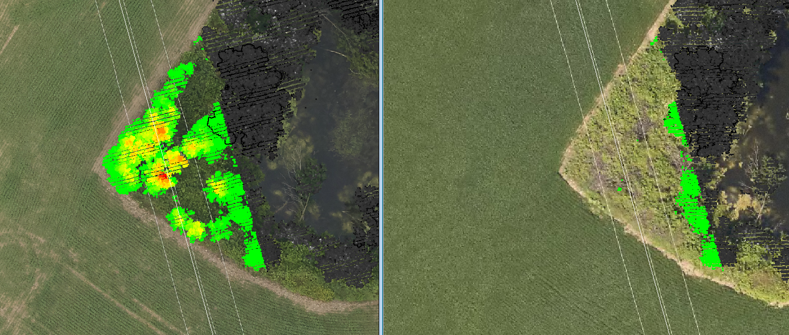
By reviewing the newly acquired data, NM Group and customer stakeholders were glad to confirm that the vegetation infringement had been fully cleared. Where there had once been a critical vegetation risk, there was now a clear and safe transmission corridor. Following the second survey, we confirmed the length and volume of vegetation cut quickly. We also updated the values for the proximity of the nearest trees on said span. This example underscores the effectiveness of a data-driven and timely vegetation management process. Where proactive planning of routine transmission corridors is complemented by scalable collection of remote sensing data and rapid, 100% accurate analysis of possible faults, the improved efficiency and targeted efforts to address the highest priority risks can increase reliability whilst keeping the overall program costs low.
Auditing
LiDAR technology is an invaluable tool for both planning and auditing vegetation management. It allows utilities to identify vegetation encroachments, plan precise clearance activities, and audit the work post-cutting. By providing detailed, location-specific data, LiDAR helps utilities allocate resources efficiently and ensure compliance with safety standards. Where LiDAR is collected regularly (for example, annually) and vegetation management work is recorded, the data lends itself to a comprehensive and highly accurate paper trail of vegetation management. From initial assessment of encroaching vegetation to post-fieldwork updates within the vegetation encroachment database to quantification and validation of actual work performed, the absolute and relative accuracy of LiDAR is unmatched. Multiple cycles of such a program can enable further reliability-increasing options like vegetation growth analysis and predictive analytics.
Collaborative Success for the Industry
This case exemplifies the power of collaboration between cutting-edge technology providers and proactive utility operators. NM Group's ability to deliver high-resolution LiDAR data free of false positives in near real-time enables our clients to act swiftly and decisively. The outcome highlights the value of rapid identification, quick response, and evidence-based documentation of possible risks to the power network.
With this approach, utility companies can ensure that no issue goes unnoticed and that risks are addressed promptly, safeguarding both the network and the communities it serves.